Dim Pahar, Bandarban: How to Reach, Stay, and What to See
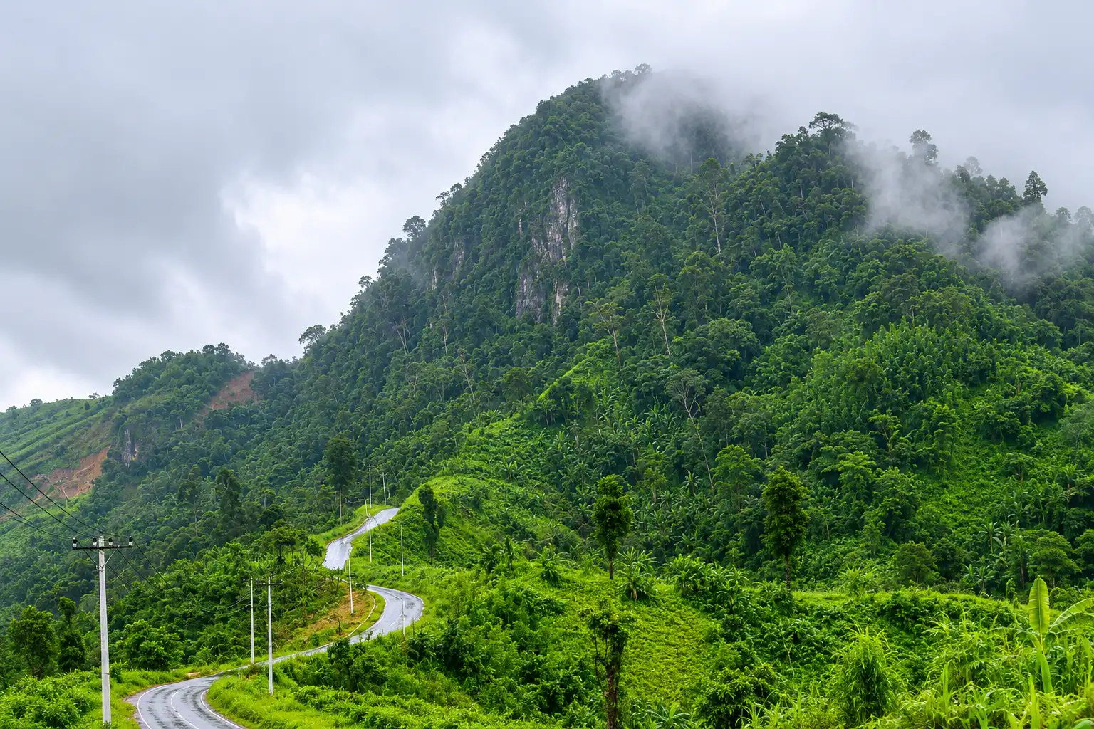
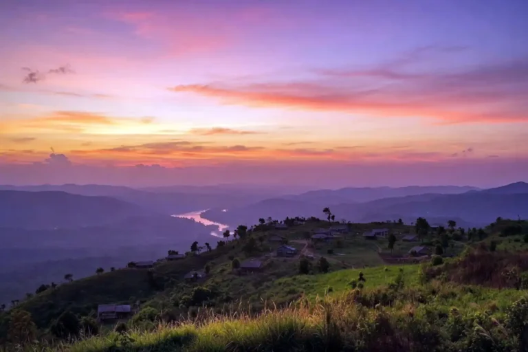
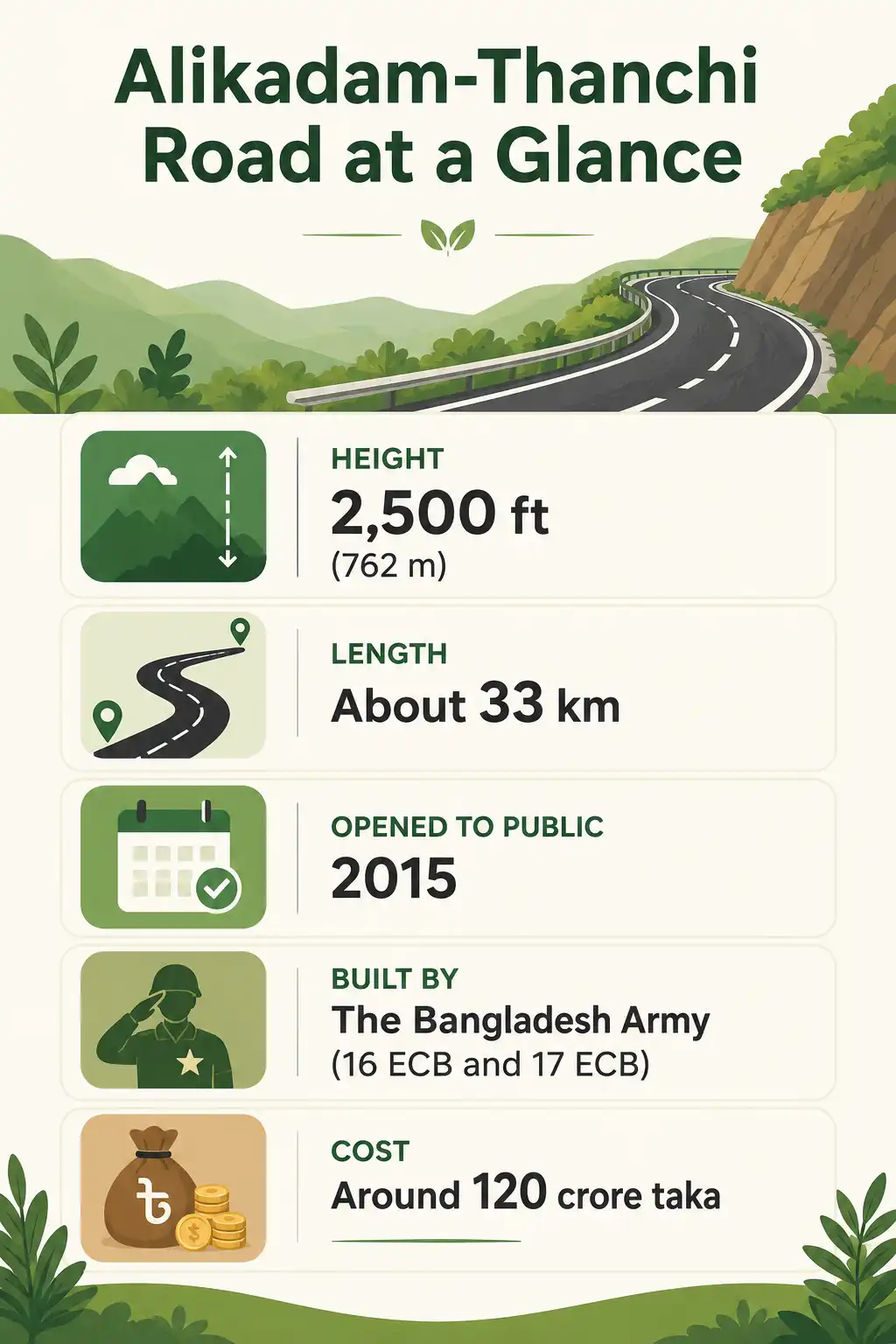
Dim Pahar is one of the most striking spots in Bandarban, and it sits on the highest road in the Bangladesh. Dim Pahar (ডিম পাহাড়), meaning “Egg Hill” in Bengali, is a hill on the border of Alikadam and Thanchi upazilas in Bandarban, Bangladesh. The highest road in the country runs across its top at roughly 2,500 feet, which is about 762 meters. Local people named it for the egg-shaped summit, and the hill itself fixes the boundary line between the two upazilas.
Quick note for 2026: The Thanchi and Alikadam areas reopened to tourists in 2025, but you should travel with a registered local guide and register your details at the check posts along the road. Rules in this border region change often, so confirm the current status before you set out.
Where is Dim Pahar located?
Dim Pahar sits right between Alikadam and Thanchi, two upazilas of Bandarban district. The hill marks the dividing line between them, which is a fun detail that few hills can claim. The Alikadam-Thanchi Regional Road climbs straight over it, and that road holds the title of the highest in Bangladesh. Because Bandarban borders Myanmar to the east, this is deep hill country, far from any city. Many travelers pair the trip with other highlights nearby, and the cloud-covered ridges like Nilgiri are not far away either.
See more: How to Reach Toma Tungi Resort
Why is it called Dim Pahar?
The name comes straight from the shape of the hilltop. At around 2,500 feet, the peak curves like an egg, so the local communities started calling it Dim Pahar. In Bengali, “dim” means egg and “pahar” means hill. The surrounding area is home to the Mro people and other indigenous communities, and their daily life and culture add a lot to the journey. After the long climb, the egg-shaped crest is an easy landmark to spot.
The highest road in Bangladesh
The road over Dim Pahar is the Alikadam-Thanchi Regional Road, and at about 2,500 feet it is the highest in Bangladesh. It runs roughly 33 kilometers and links the two upazilas. Many people also describe it as the second-highest road in South Asia. Either way, the climb is the main reason adventure travelers keep coming back.
The history behind it is worth knowing. The Roads and Highways Department began the work in 1999, but the team managed only about 8 kilometers before the steep terrain became too hard to handle. After that, the Bangladesh Army’s Engineer Construction Battalion units, 16 ECB and 17 ECB, took over the project. Then they finished it after roughly a decade of work. The project cost around 120 crore taka, and three soldiers from the engineering corps died in accidents during construction.
The road opened to the public on July 14, 2015. Before it existed, the trip between Thanchi and Alikadam ran close to 190 kilometers around the hills. Now it is only about 33. That single road turned a remote, hard-to-reach hill into one of Bandarban’s most popular drives.
Why do cars seem to roll uphill at Dim Pahar?
Some visitors report that a car left on parts of the road appears to drift uphill on its own. This is an optical illusion, the same effect seen at so-called gravity hills around the world. The slope of the land and the layout of the surrounding hills trick your eyes, so a gentle downhill can look like an uphill. Drivers here still park carefully because of it. Personally, I treat it as a fun quirk of the place and nothing to worry about.
How to reach Dim Pahar
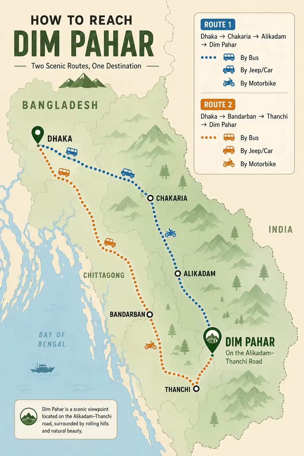
Reaching Dim Pahar takes two legs. First you get to either Alikadam or Thanchi, and then you ride the regional road up to the hill. Two main routes work well, so pick the one that fits your plan.
Route 1: Dhaka to Alikadam
Direct buses run from Dhaka to Alikadam, which is the simplest option. Alternatively, you can take a night bus from Dhaka to Chakaria in Cox’s Bazar district, then catch a local or reserved chander gari, the open jeeps used across the hills, or a local bus on to Alikadam. From Alikadam, reserve a chander gari or hire a motorbike and follow the Alikadam-Thanchi road up to Dim Pahar. After the hill, many travelers eat at Thanchi bazar and return through Bandarban, while others simply head back the way they came to Alikadam.
Route 2: Dhaka to Bandarban to Thanchi
You can also approach the hill from the Bandarban side. From Dhaka, first travel to Bandarban town, and then take a local bus or chander gari to Thanchi bazar. At Thanchi, you will find chander gari and motorbikes that run up to Dim Pahar. Thanchi also sits on the Sangu River, so this is the launch point for boat rides toward Remakri and other treks. If you are building a longer Bandarban loop from the Chittagong side, the cloud viewpoint at Mirinja near Lama makes an easy stop along the way.
Should you ride a bike or take a jeep?
A motorbike is the most popular way to ride the Alikadam-Thanchi road, mostly because it lets you stop anywhere for photos. However, the route is high, winding, and remote, so only experienced riders should attempt it. A reserved chander gari is the safer choice for families and larger groups. Either way, start early in the day so you finish the climb in good light.
Where to stay near Dim Pahar
There is no hotel on the hill itself, so most people stay in Thanchi or Alikadam. In Thanchi, you can contact the Border Guard Bangladesh (BGB) resort, and the Thanchi bazar area has a few basic hotels and cottages as well. In Alikadam, options on the newer upazila road include The Damtua Inn (01748-912127) and the Zilla Parishad Dak Bungalow, which is the district council rest house. Rooms here are simple and limited, so it helps to book ahead during the busy season.
Food and dining
You will find local food hotels in Thanchi, Alikadam, and Panbazar. The food is plain but decent, and it does the job after a long ride. For meals, expect rice, chicken, other meat dishes, and fish. Because stops on the road itself are few, carry some snacks and water with you for the climb.
Best time to visit Dim Pahar
The best time to visit Dim Pahar is from November to April, when the weather stays cool and dry and the roads are far safer. During the monsoon, from about June to September, clouds roll across the hilltop and the views turn dramatic. However, the road also gets slippery and risky in heavy rain. So if road safety matters most to you, stick to the dry months and save the cloud chasing for a calmer day.
Is Dim Pahar open to tourists in 2026?
Access to this area reopened in 2025, though a few rules apply and they can change. Here is the current picture. The local administration lifted the long travel ban on Thanchi and Ruma in June 2025, after about two and a half years; Alikadam had already reopened earlier. That earlier ban followed security operations linked to the Kuki-Chin National Front (KNF) in the hills.
Under the current rules, you should travel with a registered district or upazila guide, register your details at the check posts along the route, and stay within the areas open to visitors. Because this is a sensitive border region and the rules here have shifted several times, confirm the latest status with the local administration or at the check posts before you go. I always check the current situation myself before any Thanchi-side trip.
Travel tips for Dim Pahar
A little preparation goes a long way out here. Keep these points in mind before the ride.
- Carry your national ID card or passport, because you may need to show it at the check posts.
- Bring enough cash, since ATMs and card payments are scarce in the hills.
- Pack water, snacks, a power bank, a small first-aid kit, and a warm layer for the cold at the top.
- Mosquito protection helps a lot on the trails and at night, so it is worth knowing how to keep mosquitoes off while you hike.
- Respect the Mro and other indigenous communities, and always ask before photographing people.
- Phone signal is patchy, so tell someone at home your route and rough timing.
Extend your trip
If you have spare days, the region rewards a longer stay. On the Alikadam side, the waterfall trek out of Alikadam makes a strong add-on after Dim Pahar. From the Thanchi side, many travelers continue up the Sangu River to the Nafakhum waterfall trek, one of the most famous waterfalls in the country. Both options sit close enough to fold into a single Bandarban trip.
FAQs on Dim Pahar Travel
How high is Dim Pahar?
Why is it called Dim Pahar?
Can you visit Dim Pahar by motorbike?
Do you need a guide and permission to visit?
Which town is the base for food and lodging?
Final thoughts
Dim Pahar pays back the long ride to get there. You stand on the highest road in Bangladesh, with hills rolling out on every side and cool air even in the summer heat. For the smoothest trip, plan for the dry season, line up a registered guide, register at the check posts, and keep your schedule flexible. Then pair the hill with a night in Thanchi or Alikadam and a side trip to a nearby waterfall. Go prepared and travel light, and the hill country will handle the rest.