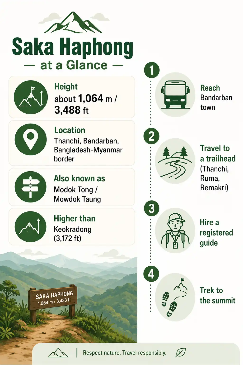
Saka Haphong Trek: Routes, Permits, and Tips for the Summit
Saka Haphong (Bengali: সাকা হাফং) is widely considered the highest mountain peak in Bangladesh, sitting right on the Bangladesh-Myanmar border in Thanchi, Bandarban. It carries no official government title, yet GPS readings and satellite mapping point to it as the tallest point in the country. Many trekkers simply call it the Everest of Bangladesh.
How do you reach Saka Haphong?
Reaching Saka Haphong takes a long bus ride and a multi-day trek deep into the Chittagong Hill Tracts. Here is the trip in four steps.
- Travel to Bandarban town by overnight bus from Dhaka, or come through Chittagong first.
- Reach a trailhead at Thanchi, Ruma Bazar, or Remakri, depending on the route you pick.
- Hire a registered local guide and check in at the security posts along the way.
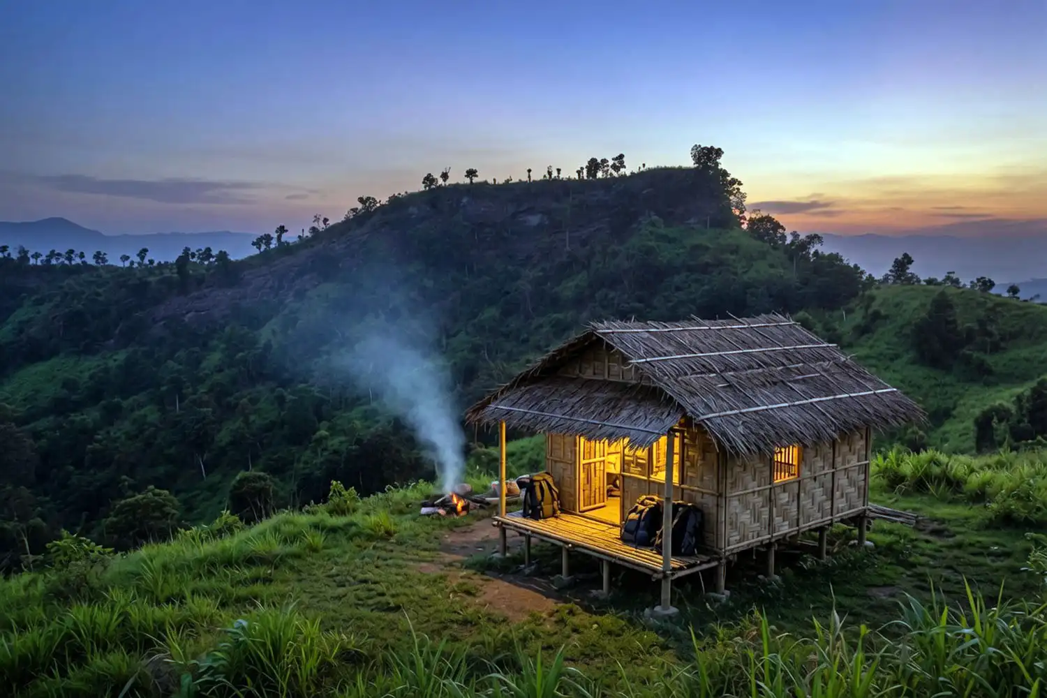
- Trek to the summit, sleeping in indigenous para homes or your own tent each night.
Before you go: A registered local guide is mandatory on this route. The Bandarban administration reopened the Thanchi and Ruma trekking zones in June 2025 after a long closure, but travel stays limited to approved areas and you must inform the checkposts. Because the security situation near the border has shifted before, confirm the current rules with the district administration first. The drier, cooler months from November through February give you the safest window for the stream crossings.
Where is Saka Haphong located?
Saka Haphong stands in Thanchi Upazila of Bandarban District, on the Bangladesh-Myanmar border. The summit sits inside the greater Mowdok range, with Myanmar’s Chin State on the far side. This is some of the most remote terrain in the Chittagong Hill Tracts, far past the last roads and well beyond mobile coverage.
The peak goes by more than one name. Locals and trekkers know it as Saka Haphong, but you will also see it written as Modok Tong or Mowdok Taung, an older name that appears on British-era topographic maps of the region.
See more: Golden Temple Bandarban: How to Visit, Reach
How tall is Saka Haphong?
Saka Haphong rises to roughly 1,064 meters, or about 3,488 feet, based on the figures most trekking teams use. That height comfortably passes Keokradong, the long-recognized summit at 3,172 feet, which is why so many people now treat Saka Haphong as the country’s true high point. If you want a sense of how the older champion compares, my full write-up on the climb up to Keokradong peak covers its routes and cottages in detail.
The exact number is still unsettled. Satellite mapping puts the summit slightly lower, around 1,052 meters, while two separate trekking clubs recorded 3,488 feet and 3,461 feet. The differences come down to GPS accuracy and survey method, so I treat 1,064 meters as a working figure rather than a fixed fact. Either way, it clears every other measured peak inside Bangladesh.
Who first climbed Saka Haphong?
English adventurer Ginge Fullen recorded the first GPS reading at the summit in February 2006, logging a height of about 1,064 meters. His coordinates lined up almost exactly with Soviet topographic mapping and SRTM data, which gave the peak real credibility as the country’s high point.
The first Bangladeshi team followed in 2007, led by Yahya Khan, with Everest summiteer Sajal Khaled among the group. For a while afterward the route went by the name Tlangmoy. Then in 2011, another expedition climbed the peak and measured 3,488 feet, and the name Saka Haphong stuck from that point on. So the mountain you read about today carries a name only a little over a decade old, even though the summit itself is far older.
How do you get to Bandarban?
Every Saka Haphong trip starts in Bandarban town, and most travelers get there by overnight bus from Dhaka. Companies like Shyamoli, Hanif, Saint Martin, and Desh run daily AC and non-AC coaches from the Kalabagan and Arambagh areas. Non-AC fares usually fall around 550 to 750 taka, while AC seats run closer to 1,200 to 1,500 taka. Take a night bus and you will roll into Bandarban by about 7 in the morning, ready to push on toward the hills.
You can also come by train or flight to Chittagong, then continue to Bandarban by road. Buses leave from the Baddarhat and Dampara stands for around 220 taka per person, and a reserved microbus costs roughly 3,000 to 3,500 taka. Prices here are approximate and pulled from local rates, so treat them as a guide and confirm at the counter, since fares move around with fuel costs and season.
What are the trekking routes to Saka Haphong?
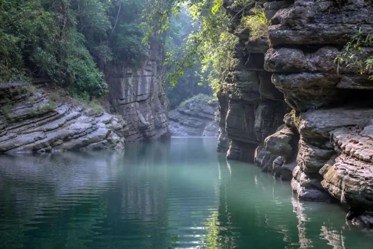
Three main routes lead to Saka Haphong, each starting from a different town: Remakri, Thanchi, or Ruma. All of them are long, physically hard treks over hill trails, stream beds, and rocky canals, so your route choice depends on fitness, time, and what your guide advises for current conditions. Below are the common variations trekkers use.
The Remakri route
The Remakri side starts you near the Sangu River and threads past some of the most famous waterfalls in Bandarban. Many groups break the journey with a stop on the trail beyond Nafakhum, then climb on toward the summit paras. Common variations:
- Nafakhum → Dula Para → Sajai Para → Nefiu Para → Summit
- Nafakhum → Jinna Para → Amiakhum → Sajai Para → Summit
- Nafakhum → Jinna Para → Amiakhum → Satvai Khum → Hanjrai Para → Summit
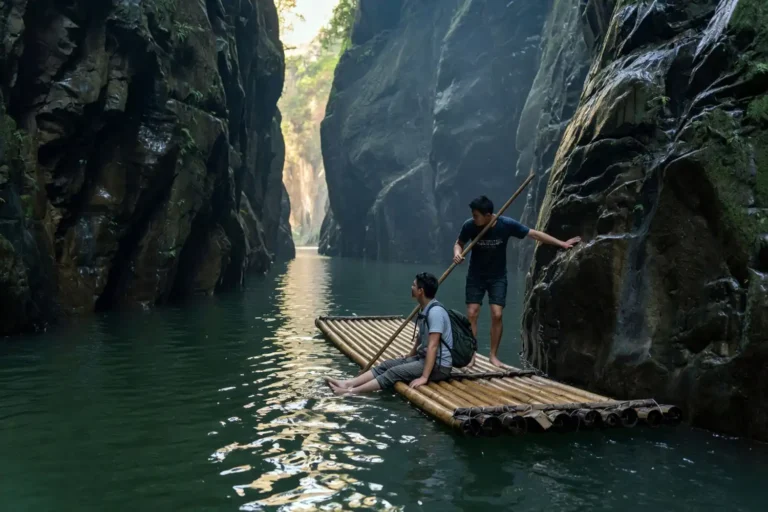
Two of these variations push through the trek to Amiakhum, which is a serious river and rock section in its own right. Plan for slow going here, because wet stone and current both slow you down.
The Thanchi route
The Thanchi side runs through Boarding Para and over the high ground near Tajingdong before reaching the summit ridge. This route often involves long stretches along a jiri, the local word for a small hill stream you walk straight up. Common variations:
- Thanchi → Boarding Para → Sherkar Para → Tajingdong → Simpampi Para → Hanjrai Para → Nefiu Para → Summit
- Thanchi → Boarding Para → up the jiri to Kaitong Para → follow the jiri to Simpampi Para → Hanjrai Para → Nefiu Para → Summit
The Ruma route
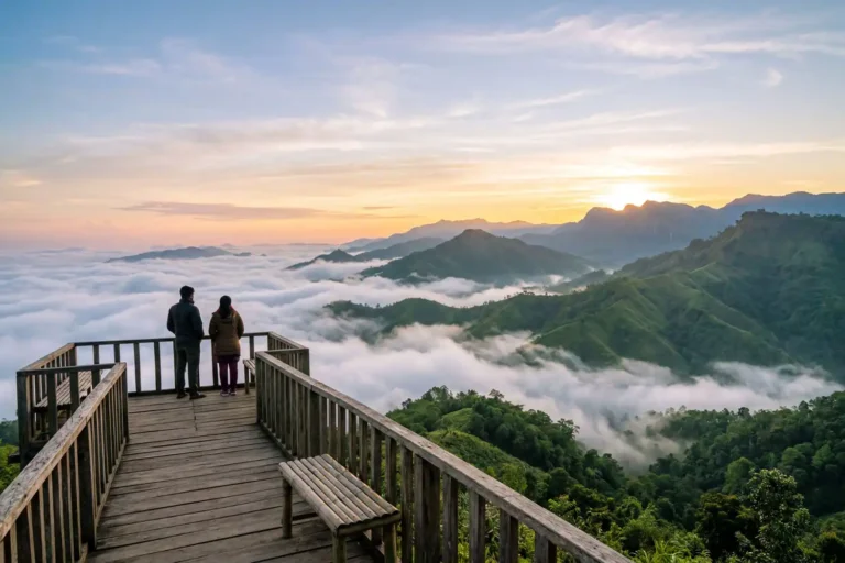
The Ruma side is the one most hikers already know part of, since it climbs past Boga Lake and over Keokradong before turning toward Saka Haphong. If you have already done the trek up to Boga Lake, the first stretch will feel familiar. Common variations:
- Boga Lake → Keokradong → Thaikyang Para → (via New Bom Para) Dulachoron Para → Hanjrai Para → Nefiu Para → Summit
- Boga Lake → Keokradong → skip Thaikyang Para, turn right at the graveyard, pass below Taml Para to the Remakri canal → New Bom Para → follow the canal to Dulachoron Para → Nefiu Para → Summit
- Boga Lake → Keokradong → Baklai → Simpampi → optional Tajingdong summit → drop down to the Remakri canal → Hanjrai → Nefiu → Summit
Where can you stay near Saka Haphong?
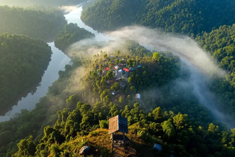
Past Ruma, Thanchi, and Remakri there are no hotels or resorts, so you sleep in the homes of indigenous families along the way. These para houses keep simple but solid arrangements for travelers, and your guide handles the bookings as you go. On this long route you pass through one para after another, and almost everyone spends the night in these villages, which are safe and welcoming. If you would rather camp, you can, but then you have to carry your own tent and set up near a para.
Where do you eat on the trek?
After Ruma and Thanchi, your meals come from the same indigenous homes where you sleep. The hosts cook well for trekkers, and a typical plate includes rice, vegetables, dal, aloo bhorta, and chicken. Tell your guide ahead of time what you want, and he arranges it at each stop. Still, I always carry light dry food too, like dates, biscuits, chocolate, chira, puffed rice, and fruit, for the long gaps between meals.
You will also find small grocery shops in some paras selling soft drinks, biscuits, and bottled water, plus seasonal hill fruit worth trying. The trek itself is hard work from start to finish, so your body burns through energy fast. For a fuller picture of what keeps you moving, here is how I think about fuel for a long day on the trail.
Saka Haphong safety tips and packing list
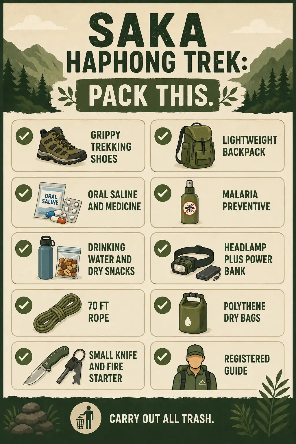
Good preparation matters more on this trek than on almost any other in Bangladesh, because help is far away once you leave the last town. The points below come from the way experienced hill trekkers pack and behave on this route.
- Carry out all your trash. Never leave food wrappers, chip packets, cigarette filters, water bottles, or any other litter on the trail.
- Wear shoes with strong grip. The trail mixes mud, wet rock, and stream beds, so traction keeps you upright.
- Use a shoulder backpack and keep the weight low. Every extra kilo costs you on the climbs.
- Pack plenty of food, oral saline, your regular medicine, and a malaria preventive.
- Keep enough drinking water and dry snacks within reach at all times.
- Bring a good torch or headlamp, spare phone batteries, and a power bank. If you are unsure how bright to go, here is a quick read on the headlamp brightness you actually need.
- Carry a sturdy rope about 70 feet long, plus enough polythene bags to keep everything in your pack dry during crossings.
- Pack a small knife and basic fire-starting gear.
- If you can, bring someone on the team who has summited Saka Haphong before.
- Always trek with a registered guide. This is both a rule and plain common sense.
FAQs on Saka Haphong
Is Saka Haphong the highest peak in Bangladesh?
Do you need a permit and a guide for Saka Haphong?
How many days does the Saka Haphong trek take?
What is the best time to trek Saka Haphong?
Final thoughts
Saka Haphong is the most demanding trek I would point a fit, prepared hiker toward in Bangladesh, and the payoff is standing on what is almost certainly the country’s highest ground. Get to Bandarban, pick a route through Remakri, Thanchi, or Ruma, pack light but smart, and go with a registered guide who knows the current conditions. Respect the rules, carry out your trash, and check the access situation before you commit. Do that, and the long climb to this border summit becomes one of the best things you can do on two feet in the hill tracts.