Everest Base Camp Trekking Map: Full Route, Stops, and Distances
The Everest Base Camp trek follows a well-marked route through the Khumbu region of Nepal. I get a lot of questions from readers about what the actual trekking map looks like, where each stop sits, and how the elevation climbs day by day. So I put this guide together to lay out the whole route plainly. You will find the standard 12-day itinerary, key villages, altitude markers, and the side trails that matter. By the end, you will know exactly what the EBC trail looks like from Lukla to base camp and back.
What does the Everest Base Camp trekking map show?
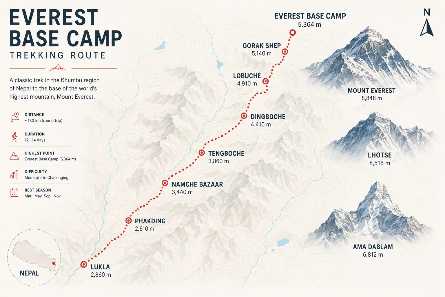
The Everest Base Camp trekking map shows a roughly 130-kilometer round-trip route from Lukla to base camp at 5,364 meters, passing through Sherpa villages, suspension bridges, monasteries, and high-altitude valleys. The trail follows the Dudh Koshi river upstream, then climbs into the Khumbu valley, and finally ends at the foot of the Khumbu Icefall. Most maps also mark acclimatization side trips, like the climb to Kala Patthar at 5,545 meters for the classic Everest viewpoint.
Standard EBC route overview
The trek starts after a short flight from Kathmandu to Lukla airport at 2,860 meters. From there, you walk north through the Khumbu valley. The path crosses the Dudh Koshi several times on suspension bridges, then climbs through pine and rhododendron forest, and finally breaks above the treeline near Dingboche. After Dingboche, the landscape turns to bare rock, glacial moraine, and ice. For a wider view of how this fits into Nepal’s other high-altitude routes, I wrote a separate piece on Himalayan base camp trekking in Nepal.
Day-by-day trekking map breakdown
Day 1: Lukla to Phakding (2,610m)
The first day is short. After landing at Lukla, you walk downhill for about three hours to Phakding. Distance is around 8 kilometers. So the gentle descent helps your legs warm up without pushing altitude too hard on day one.
Day 2: Phakding to Namche Bazaar (3,440m)
Day two is the first hard day. The trail follows the Dudh Koshi, crosses the famous Hillary Bridge, then climbs steeply for about 600 meters into Namche Bazaar. The distance is around 11 kilometers and takes 6 to 7 hours. Namche is the main Sherpa town in the region.
Day 3: Namche acclimatization
You rest in Namche, but not by sitting still. Most trekkers hike up to the Everest View Hotel at 3,880 meters and return the same day. This “climb high, sleep low” approach helps your body adjust. Skipping this day causes serious altitude problems for many people.
Day 4: Namche to Tengboche (3,860m)
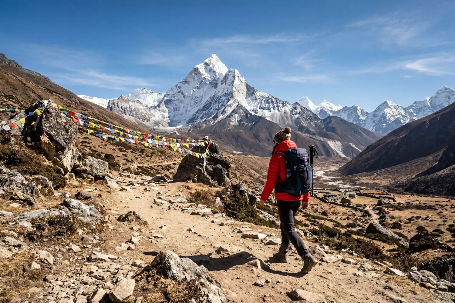
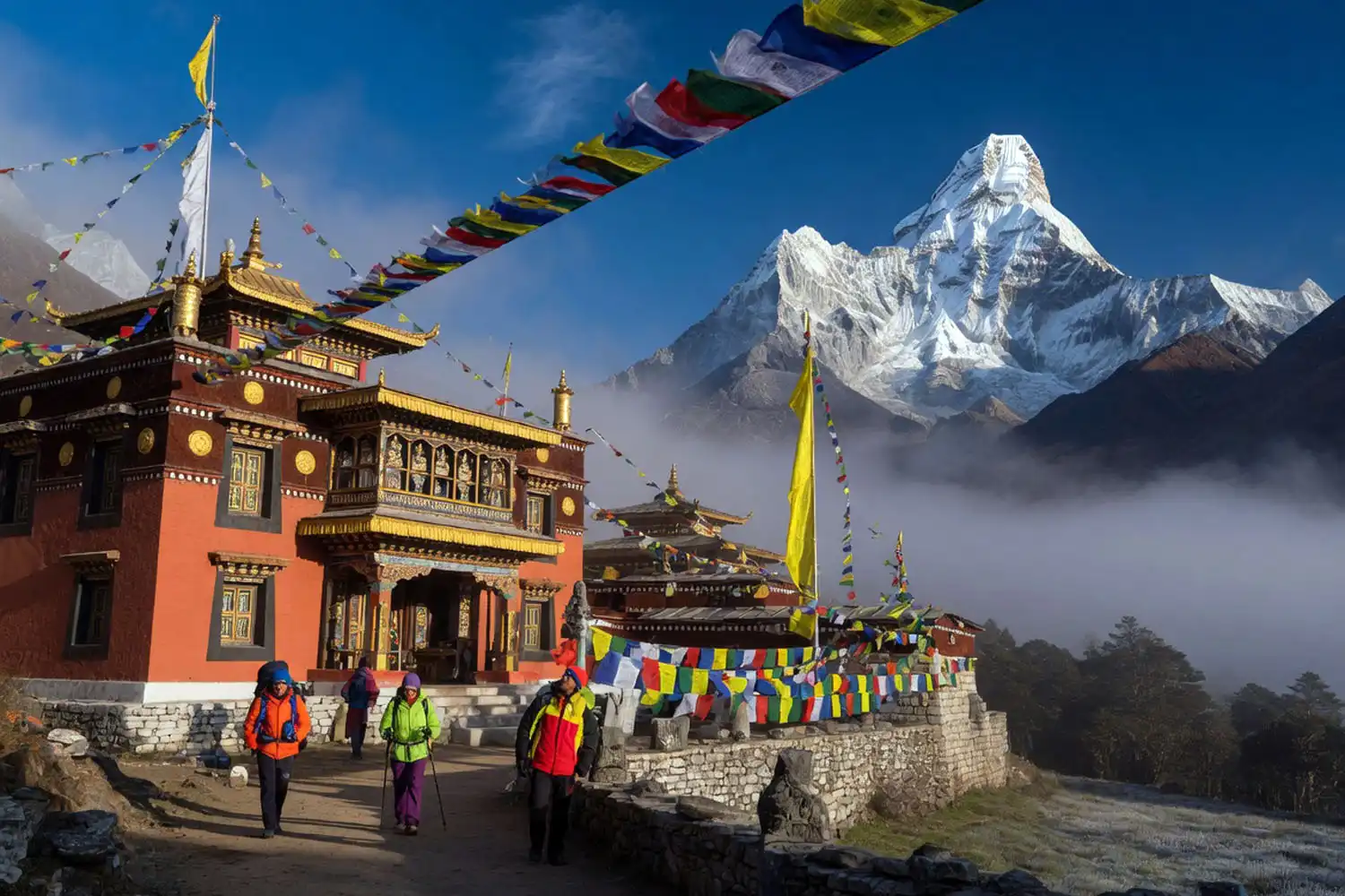
The trail climbs gradually, then drops to the Imja Khola river before climbing again to Tengboche. The famous Tengboche Monastery sits here, framed by Ama Dablam. Distance is around 10 kilometers.
Day 5: Tengboche to Dingboche (4,410m)
After Tengboche, the forest thins out. You walk into the upper Khumbu, passing Pangboche village and stone fields. Dingboche is the first stop above 4,000 meters where the air gets noticeably thin.
Day 6: Dingboche acclimatization
Another rest day. Most people climb Nangkartshang Peak (5,083m) and come back down. So this gives your blood a chance to make more red cells before you push higher.
Day 7: Dingboche to Lobuche (4,940m)
The trail crosses Thukla Pass, where stone memorials honor climbers who died on Everest. After Thukla, the path follows the lateral moraine of the Khumbu Glacier into Lobuche.
Day 8: Lobuche to Gorak Shep to EBC (5,364m)
This is the big day. You walk to Gorak Shep at 5,164 meters, drop your pack, then continue to Everest Base Camp at 5,364 meters. Round-trip from Lobuche is about 15 kilometers and takes 7 to 8 hours.
Day 9: Kala Patthar and descent
Most trekkers wake before dawn to climb Kala Patthar at 5,545 meters for sunrise over Everest. Then you descend to Pheriche or Pangboche.
Days 10–11: Return to Lukla
You retrace the trail down through Namche and back to Lukla. Going down feels faster, but the steep descents are hard on the knees.
Day 12: Lukla to Kathmandu
A morning flight ends the trek.
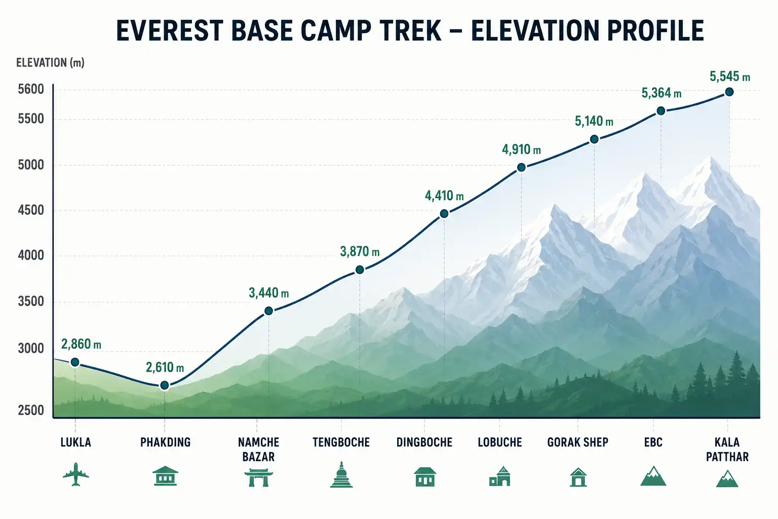
How long is the Everest Base Camp trek in total?
The full round-trip is about 130 kilometers (80 miles), walked over 12 days including two acclimatization stops. Daily distances range from 6 to 15 kilometers, but the elevation gain matters more than the mileage. For a deeper breakdown of pace and timing, I covered the walking schedule for EBC in a separate guide.
Key elevation points on the EBC map
Here are the main altitude markers you will see on any printed map:
- Lukla: 2,860m
- Namche Bazaar: 3,440m
- Tengboche: 3,860m
- Dingboche: 4,410m
- Lobuche: 4,940m
- Gorak Shep: 5,164m
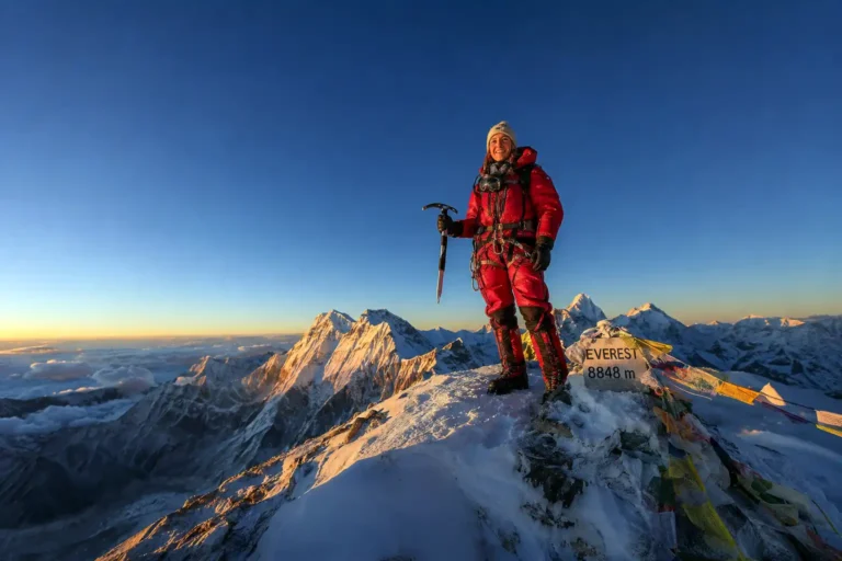
- Everest Base Camp: 5,364m
- Kala Patthar: 5,545m
The full elevation profile climbs about 2,500 meters from Lukla. I broke down the base camp altitude in detail if you want to understand why oxygen drops so sharply above Dingboche.
Are there alternate routes on the EBC map?
Yes, three popular variations exist. The Gokyo Lakes route loops through the Cho La Pass and joins the main trail near Lobuche, adding 4 to 5 extra days. The Three Passes trek crosses Renjo La, Cho La, and Kongma La. Also, some trekkers fly into Phaplu or Salleri and walk for several extra days instead of using Lukla.
What does the map show beyond base camp?
The map continues past Everest Base Camp to the Khumbu Icefall, but trekkers cannot enter the icefall. That section is reserved for climbing expeditions. The icefall leads to Camp 1, Camp 2, and the higher camps on the mountain. I wrote a separate guide that walks through the full camp system on Everest if you want to see how the climbing route continues above base camp.
Safety markers on the trekking map
Several places on the map matter for safety reasons. Pheriche has a Himalayan Rescue Association aid post staffed during peak season. Namche has the only hospital in the Khumbu region. Helicopter evacuation points exist near Lukla, Namche, Pheriche, and Gorak Shep. So always note these locations before you start. According to the Himalayan Database, altitude sickness causes most evacuations on this trail.
Tips for reading the EBC trekking map
Most printed maps use 1:50,000 or 1:100,000 scale. So contour lines matter more than raw distance for planning. A short kilometer at 5,000 meters takes far longer than the same kilometer at 3,000 meters. Mark teahouses, water sources, and clinic locations before you go. Also bring a paper backup, because GPS apps can fail when batteries freeze at high altitude.
For fitness planning, I shared what shape you need to be in for multi-day mountain trekking based on my own hikes in Bandarban and what I have read from EBC veterans.
Final thoughts
The Everest Base Camp trekking map is more than a path on paper. It shows a 12-day journey through the Khumbu, with two built-in acclimatization stops and a steady climb from 2,860 meters at Lukla to 5,364 meters at base camp. Print a good topographic map, study the elevation profile, and learn where the medical posts sit. Then trust the trail. Thousands of trekkers complete this route every season, and the map has been refined over decades to keep you safe.